Thursday 28 February 2019

Some WWII Direction Finding Sites in Shetland - Part 2 (amended 30 Mar 19)

Very High Frequency (VHF) DF Sites (amended 30 Mar 19)


I have visited 3 places in Shetland where I believe that construction of VHF DF sites took place; at the western end of Crussa Field on Unst, just north of Isbister on "Willies Wart", Whalsay and at Eshaness on the Shetland Mainland. A fourth site on the Hill of Swinister, south of Firth, also on the Shetland Mainland, was recently brought to my attention. The Shetland sites appear to have been planned to the same design but the first 3 I mentioned did not become operational and I don't know enough about the site on the Hill of Swinister to make any comment on whether it achieved active status. To begin with in this section I will describe  the remains at each location and, in succeeding paragraphs, information from similar sites in the rest of UK will be used to attempt to learn more about the 4 Shetland VHF DF units.
VHF D/F site on Crussa Field, Unst. The re
mains at this position are the least recognisable of the 3 and I cannot be absolutely certain that it was a D/F site!. It was begun on the western side of Crussa Field, a few hundred yards west of the Rounds of Tivla. A slightly raised area of soil with, what appears from a distance as  a short, low section of wall, on the northern side of the raised ground.

On closer inspection the raised area appears octagonal in shape and small traces of broken glass and coal were discovered within its boundaries.  There is no solid foundation below  the 8-sided section as, when visited, there were 2 deep rabbit holes in it. The "wall" consisted of a coarse mixture of cement with sand and contained numbers of sea shells:
Nothing was found to suggest that any structures on the site were completed.

VHF D/F site near Isbister, Whasay.  For two reasons it is possible to describe this place more fully; firstly, there are more substantial remains and, more importantly, I was fortunate enough to meet someone who was employed during the building of the site. The construction of the operational element of the unit took place on "Willies Wart" a small hill about 280' high, just to the north of Isbister. A track had to be laid a distance of about half-a-mile from the bottom of the hill. To begin with a few  recent pictures of the location.

At the top of the hill, close to an historic cairn, a flat, octagonal shaped area of concrete about 12' to 13' across at its widest point,  can be seen:
At intervals around the octagonal shaped concrete are strong but bent bolts which were possibly used to secure something:

Close to the concrete base lies a large amount of rubble. containing  blocks which, from their content, look as if they were manufactured near to the site:

A large amount of interesting information was gathered from a few Whalsay folk. Mackie Polson was able to say that there had been 2 generators at the foot of the hill and that a cable had been laid in a ditch alongside the track up to the site. The two "engine beds" are still visible:

Mackie was also able to remember that there used to be the foundations of two nissen huts close by but that they had been hidden when more modern developments took place:

Danny Eunson was able to add the information that a Crossley 50 hp diesel generator from the site was converted to a marine engine and used to power the fishing boat the "Bonnie Isle" when she was built at Scalloway. George Polson, who was born in Isbister, was able to supply a lot of useful data. When he left school in 1943 he was employed to work with the RAF personnel who were constructing  the site. George was in the right place at the right time. He owned a Shetland pony and was engaged to transport aggregate for the track and for the foundations at the top of the Wart. His pay was 2s 6d (12.5p) an hour, more than  many a skilled craftsman could earn in those days.
He recalls that a wall was built around the octagonal foundations at the top of the hill and that a 3 storey wooden hut was put up within the wall. He thought that it was about 30' tall and a ladder was fixed at the centre enabling ascent  to the top floor - there were windows on the top floor. He remembered being on the top floor and dropping stones down through the opening for the ladder access. He didn't recollect any equipment being installed before work was discontinued.

VHF DF site at Eshaness, Shetland Mainland. The remains at this location are the most complete of the 3 Shetland sites that I have visited. An octagonal brick-built enclosure is still standing:

Outside the wall and at each corner of the octagon the stumps of inward-sloping wooden posts can be seen:
Inside the wall extensive foundations remain:
The disturbed soil from a cable run heading north-eastwards from the enclosure can just be traced. It leads to the foundation of what appears to have been 2 nissen huts:
The remains of  the southerly of these huts look like it was probably for accommodation:
The other foundations are beside the current roadway - I believe that this hut used to house generator equipment:
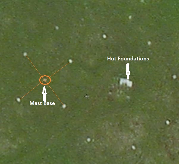
VHF DF site at Hill of Swinister, Shetland Mainland. I am grateful to Sammy Sjoberg for bringing this site to my attention. I have yet to visit the location but intend to do so when the opportunity arises. First of all, 2 photos sent to me by Sammy:


The Domestic accommodation is a few hundred yards NE of the octagonal structure. Another picture from Sammy and two pictures from Martin Briscoe:


The following aerial photo belongs to Canmore (Royal College of Ancient and Historical Monuments Scotland) and can be seen in it original context here -  http://canmore.org.uk/collection/1682616  :


In the Canmore picture above the domestic site is in the foreground, whilst the octagonal walls are just the right of the rectangular building close to the horizon in the centre of the picture. I will update the information about this site if more data becomes available.

There are numerous similar sites in the rest ot fhe UK, from Orkney to the south coast of England. Not much information is readily available about any one site but, together, the pieces of data from a number of sites can give an idea of their role/s.

Some other UK VHF D/F Sites. Some of the UK sites I have  found reference to are shown below. They all seem to have/had octagonal walls, containing octagonal  concrete foundations, in common:


Saversdale, Sanday, Orkney - http://photos.orkneycommunities.co.uk/picture/number26916.asp


Lybister, Caithness - canmore.rcahms.gov.uk/en/site/314258/contribution/lybster/
Corse Hill, Aberdeenshire - canmore.rcahms.gov.uk/en/site/142172/contribution/corse+hill/FNL7065320649/
Scotstown Moor, Aberdeenshire - 
https://www.flickr.com/photos/doffcocker/sets/72157629563035545
Near Ronaldsway, Isle of Man - http://www.island-images.co.uk/ATC/zRon1940s/z1940s.html

Llanerchymedd, Anglesey  - https://www.geograph.org.uk/photo/5408984

Llwydiarth Tower, Wales - http://trigpointing.uk/trigs/view-album.php?t=9602

Halnaker Hill in West Sussex - http://www.geograph.org.uk/photo/2969486    and https://www.youtube.com/watch?v=3vnpK1X4Od0

Garway Hill, Herefordshire -  https://www.themountainguide.co.uk/england/garway-hill-photos.htm
Orfordness, Suffolk https://en.wikipedia.org/wiki/Radio_navigation#/media/File:The_%27Black_Beacon%27,_Orford_Ness_-_geograph.org.uk_-_935140.jpgNedge Hill, Shropshire - https://www.geograph.org.uk/photo/5274112
Ibsley, Hampshire - http://www.geograph.org.uk/photo/4704961      And http://www.geograph.org.uk/photo/4704970
RAF Lasham, Hampshire - https://www.geograph.org.uk/photo/5274112

Some points for consideration.
Whilst some of the explanations with each site may vary, they seem to have some common properties. The octagonal wall contained a 3 storey "windmill" type building 25 to 30' tall. It was wooden to reduce the interference to radio signals and a number of descriptions refer to an internal ladder to the upper storey, which itself had a number of windows
Some sites mention that the wooden walls were double-skinned, the gap designed to contain stones to provide a degree of protection from attack. The need for inward-leaning wooden stanchions, with their bases outside the wall to support the wooden building, is also a recurring theme. Being VHF there was no need for large antenna, each element being just a few feet long. The next picture is from the AP2521 and shows a mobile VHF DF unit it the '50's. However it does give a good example of the size of antenna required:


The static sites would have had their antenna  rotated by some kind of mechanism from within the hut.

The power sources mentioned seem to be Lister Blackstone or Crossley generators and there is some evidence that 110 volt DC power was used. Almost all the sites listed earlier are referred to as VHF but there are variations in their assumed roles. However, the known RAF operated sites nearly all refer to a "homing" role for friendly aircraft. The three RAF sites in Shetland on Unst, Whalsay and at Eshaness were never completed and I assume that was because their designed role was better performed by more modern technology. Improved navigation systems like H2S, OBOE and the later versions of GEE were proving to be very helpful. Certainly, RAF heavier aircraft like the Lancaster, carried direction finding equipment which enabled the crews to home in on signals from ground stations - at least some of the RAF D/F units must, therefore, have been able to transmit as well as receive - ie, they were not just "listening posts"

I am indebted to Logaston Press for allowing me to reproduce the next picture. It is of a site similar to the three in Shetland - at Garway Hill in Hereford - and comes from a book entitled "Garway Hill though the Ages" - first published in 2007. The photo was taken in the mid 40's and is the best I have seen of the type of wooden hut used on these VHF D/F sites:


Image copyright Garway Heritage Group, taken from ‘Garway Hill through the Ages’ published by Logaston Press


The type of wooden hut must have continued in use long after the war. This picture is from AP 2521A and shows a hut from the early 50's, abeit with an external ladder and with the windows at a different level:
Over the years many hundreds of these VHF DF installations were constructed. The buildings were sometimes octagonal, hexagonal or quadrangular. Sometimes the huts were wooden and sometimes made of brick. Most sets were static but some mobile units were introduced. In the RAF they became known as CRDF - Cathode Ray Direction Finding - and were usually located on, or near, airfields.  A picture of a typical 1950's RAF CRDF site:


They were used as navigation aids and for early QGH landings. QGH was a term used to denote procedural descents through cloud. Using the DF site and airborne radio equipment aircrew could descend in safe areas on safe headings when the ground was obscured by cloud layers. The systems saved many lives.

I would be happy to hear from anyone who has more information about WWII D/F sites in Shetland. In the meantime, I would like to acknowledge the assistance I have received from the following sources; however, the mistakes and misconceptions are all mine!

Acknowledgements:
Stan Ames
The late Fred Barlow
Sheila & Tim Briggs
Martin Briscoe
Rita Carle
Mike Dean
Cecil Duncan
Danny Eunson
Leslie Henderson
The Late Eileen Hunter
Bob Jenner
Geordie Mainland
Mackie Polson
John Polson

Logaston Press
Whalsay Heritage (Marina Irvine)
AP2521 Chapter 4

Some WWII Direction Sites in Shetland Part 1 is here: 

https://ahistoryofrafsaxavord.blogspot.com/2019/02/some-wwii-direction-finding-sites-in.html

CONTENTS LIST

Some WWII Direction Finding Sites in Shetland - Part 1


During WWII there were a number of Radio Direction Finding (RDF) sites in Shetland. Some of these sites were to be later called Radar units after the name was introduced by the US Navy and the US entered the war. The Chain Home, Chain Home Low,  Naval Coastal Defence U-boat and Army Gun Laying sites all became known as having Radar equipment. However, there were a number of other sites which used RDF principles, often referred to as "listening posts" or, more simply, as Direction Finding (D/F) units. Some of these D/F units will be discussed in this article.
The nature of the work was highly classified and few personnel were attached to each unit - these factors have led to there being little information readily available about this subject. When researching some of the locations most information has been gleaned from the foundations which remain long after the war and from a few contemporary  anecdotes - much of the chronology and the roles of these units has had to be assumed. I have also been fortunate to receive assistance from a number of helpful individuals.  There may well be other locations in Shetland I have not discovered and I am no expert in the technology involved. I hope this article encourages people with more details to get in touch.
The roles of the units varied with some of them having more than one purpose. Some were designed to be "listening posts "- just to monitor enemy transmissions, others were used for the detection and location of enemy assets (submarines, surface shipping or aircraft). A few sites worked as "beacons", transmitting signals to help allied aircrew to determine their location, eg after bombing missions. when accurate information was sometimes needed to help recovery to airfields. In Shetland these D/F units were intended to work in the Medium Frequency, High Frequency or Very High Frequency Bands (MF = 300kHz to 3mHz, HF = 3MHz to 30MHz and VHF  = 30MHz to 300MHz). As a general rule the lower the frequency the longer the antenna required.  I will deal with the units I have researched by Frequency Band and, because of software limitations, I have had to issue the article in 2 parts.  This section covers the Medium and High Frequencies:

Medium Frequency (MF) Sites.
I have visited two MF sites, both just north of Sumburgh Airfield at the south of the Shetland Mainland, one belonging to the Air Ministry and the other to the Admiralty.


Both of these sites required 4 masts, each of them probably 70' tall, to support their antenna. The lower part of each mast would have looked similar to that in this picture from Stan Ames


I believe that they were both equipped with Marconi DFG.20 Direction Finders. 
They were situated on the eastern side of Ward Hill,  Dunrossness.  A few details about the Air Ministry site first.

Air Ministry MF Site: The picture below has been taken from Zoom Earth and, for clarity, I have marked the positions of the mast bases with  yellow circles:
The next picture is an enlargement of the westerly mast base and indicates the anchor points for its cables:

Each anchor point looked like this: 


and the base for each of the masts like this:


There is little of the site left to see except foundations :

Thanks to Cecil Duncan for the information that this unit was staffed by civilians seconded to the Air Ministry. The late Andrew Halcrow from Walls in Shetland was recruited by MI5 at the beginning of WWII to join a small unit initially called the Radio Security Service. A few amateur radio enthusiasts with advanced Morse skill were selected for this service and they became known as Voluntary Interceptors. During the war Andrew spent some time on the UK mainland and in Orkney He also spent some time at the Air Ministry DF station at Ward Hill. The following picture, also kindly provided by Cecil Duncan, shows a civilian operator at work on Ward Hill:

An interesting feature  of this picture is the equipment  by the wall beyond  the civilian. Behind his head is a T 1154 wireless transmitter set and lower down the corner of a R 1155 receiver can just be detected. This equipment was normal wireless equipment in the standard RAF WWII heavy bombers such as the Lancaster. Clearer images of the T 1154 and R 1155 wireless equipment can be seen in these photos from Bob Jenner:


Later Andrew was awarded the Imperial Service medal for his radio work, as can be seen in this press cutting - also provided by Cecil Duncan:

Because there was a transmitter in the Operations Hut I believe it likely that this site may have provided homing information to the crews of aircraft which had been engaged against axis targets or, possibly, for relaying messages to and from these crews.
The second MF direction finding site about which I have some information lies about 1 km NE of the Air Ministry site - at a place called Aipleton.

Admiralty MF Site.Aipleton was an Admiralty facility manned by "civilians". It had both HF and MF equipment a short distance apart.  Home Office war records list a number of Shetland sites, including:
Admiralty VP No A4105 Sumburgh Special W/T Stn
Admiralty VP No A4106 Sumburgh - Ward Hill Special W/T Stn
(VP = vulnerable point, requiring special guarding and W/T stands for wireless telegraphy)
 In the following paragraphs I will discuss the Aipleton MF element - the HF unit will feature later.  Fortunately, in 2015 I was lucky to meet Geordie Mainland who, as a teenager, worked on the site. Although in his 90's when I met him Geordie had a cheerful character and an excellent memory and I am indebted to him for some of the information below. Geordie had previously taken part in the construction of two Admiralty radar sites on Fair Isle and, when at Aipleton, his main role was as a messenger - delivering coded intercept messages to the Shetland  Naval HQ in Lerwick. From Lerwick the coded messages were forwarded to Bletchley Park for deciphering. Bletchley Park, just NW of London, was the home of the UK's WWII code breakers. Geordie was equipped with a khaki painted ex-Automobile Association BSA M20 500cc motor bike.


The Aipleton MF site had more than one receiver , though possibly no transmitter - it's specific role was intercepting & monitoring axis transmissions. Because the UK was unable to produce enough receivers of the right type an order was placed foe American equipment and numerous HRO sets were obtained  - originally brought out for the Ham radio market in about 1935. There is a story that the HRO stood for "Hell of a Rushed Order".  The set was manufactured by the National Radio Company of Malden, Massachusetts - thanks again to Cecil Duncan for the photo.

The unit was Operational from August 1939 until the end of the war. One of the Radio Operators at this site during the war was the late Fred Barlow, a civilian from Heywood in Lancashire. He  had been a sub-postmaster at a telegraph sub-post office in Blackpool before the war. His wartime  "Certificate of Employment" described him as a Civil Servant employed by The Admiralty. The Certificate also stated that he was performing "Essential Services in War". The picture below, taken from an Identity Card, shows what Fred looked like during this period:


At Aipleton Fred had to work long shifts and was not too keen to have to share his "digs" with someone else who was on shift at different periods from himself, but accommodation was in short supply. He mentioned getting away from his workplace with some of his workmates using a motor-cycle and sidecar, quite possibly the same vehicle entrusted to Geordie Mainland. On his trips home to Blackpool, where his wife had taken over his sub-post office duties, he took parcels of unrationed food, which seemed to be more readily available in Shetland. Fittingly, Fred is mentioned on the Bletchey Park Roll of Honour.

The unit was operational and the equipment was active during the hunt for the German pocket battleship Bismarck (Apr/May 41). One of the stations aims was to attempt to get a bearing on enemy radio transmissions so that the information, together with similar information from other sites, could be used to "fix" the position of enemy surface ships and U Boats by triangulation.  The other aim was to record enemy transmissions and to forward the coded signals to higher authority. The speed of analysing this information was important - hence the need for Geordies motor bike!.
The aerials were situated about 1km NE of the Air Ministry establishment and about 1km east of the main Lerwick to Sumburgh road. There was a billet, probably for some of the Admiralty/civilian personnel and a building for storing fuel, approximately 3 or 400m west of the operations/mast area.


The 4 masts were laid out in a similar fashion to those at the Air Ministry unit, each mast having 4 cable guying points:

The operations hut was located within blast walls  and the site powered by petrol powered generators. 


The MF site was manned 24 hours a day by a watch of 3 or, possibly, 4 people. 
The small, brick-built building to the south of the billet, had a metal door and was almost certainly used to store petrol for the generators and vehicles:


According to Geordie Mainland, the Commander of the site was "ex Navy", possibly an ex Swordfish gunner, who had a French sounding name.
With all the secrecy surrounding this site it is impossible to say how successful it was in providing useful data but, according to Geordie Mainland, the unit continued operations until the end of WWII.

High Frequency (HF) Sites.
There are 2 WWII H/F sites in Shetland that I have looked at closely and, possibly, a third that I was recently informed of, but I suspect that there may have been others. The 2 sites I have examined are at Aipleton, north of Sumburgh, close to the Admiralty MF site, and on Crussa Field in Unst. Before discussing more details of each site it will be simpler to describe the similarities between the sites. There were a number of types of HF D/F equipment in use by the Allies during WWII but the Aipleton and Crussa Field units were basically alike. Most D/F sites used "Adcock Antenna"  which consisted of 4 masts, equidistantly spaced in the form of a square. Each mast held an antenna, the size being dictated by the frequency used - the lower the frequency, the taller the masts.  The two MF sites operated in the range 300 kilohertz to 3 megahertz and required tall masts. The 2 HF sites discussed in this section would have worked in the frequency range 3 megahertz to 30 megahertz and therefore needed much smaller masts, about 30' in height .
The HF sites at Aipleton & Crussa Field appear to have been equipped with Marconi DFG. 24 Direction Finding sets. Operations were conducted from smaller huts which had no protective blast walls. A typical war time HF unit, similar to the establishments at Aipleton and Crussa field, is shown in the following picture: 
Each unit would possibly have had 4 personnel working watches, one man on duty at a time. Both huts would have required power from an outside  source and have had the means to pass on significant data rapidly (phone/radio). Apart from a receiver the hut would have been equipped with an item called a goniometer, like the large, circular display near the centre of the next picture, which was taken in England during 1943:
Now to look at the Aipleton HF site specifically:

Aipleton HF. The foundations of this unit are a short distance north of the MF site and, at ground level, they can be difficult to locate. The HF equipment used power from the generator/s within the MF site blast walls. In places it is just possible to see where the power cable trench was dug and, although it may mean leaping a few drainage ditches, it is possible to follow the route which can be seen faintly in the Zoom Earth image below:
The remains of the foundations look like this:
and each mast base looks similar:
When the site was constructed 4 x trenches were dug radiating from the hut in approximately  N,S,E & W directions. Copper tape and/or wire was laid in these trenches to provide screening to help amplify the radio signal (or possibly just for earthing).

The establishment was closely associated with the MF site and some of the personnel possibly shared the same billet. According to Geodie Mainlland the hut was usually inhabited by one person at a time and Geordie did not relish approaching it to deliver or receive messages, especially during the hours of darkness.  The single occupant was armed with a loaded revolver and always drew the weapon before opening the locked door to see who was outside.
With the secrecy which surrounded such units it has not been possible to discover any official accounts detailing the specific work carried out from the site but, like the adjacent MF site, it was operational from Aug 39 until the end of the war.

Crussa Field, Unst HF.
The layout of this unit was very similar to the one at Aipleton just described. However, Aipleton was controlled by the Admiralty, whereas, this unit came under the Air Ministry. It was situated on Crussa Field to the NW of Baltasound and just SE of the archaeological site known as the Rounds of Tivla. Once again, as with Aipleton,  I was fortunate enough to talk about the site with someone who had actually seen it when it was operational. The late Eileen Hunter of Baltasound was just a child about 7 years of age when she visited the hut but, luckily, Eileen was possessed of a marvellous memory.  Four of the RAF personnel who worked on the Unit were actually billeted at Eileen's family home, Milbrae at Baltasound and she remembered their names. They were: Leslie Sessions, Larry Perkins,  Tony Hunter and W.E. (Gerry) Gerrard. Gerry Gerrard returned to Uns t on holiday after the war. He was a commercial artist in civvy street and was known to be quite a character - a copy of one of his sketches below:  

The remains of the HF site are not as well preserved as those at Aipleton, possibly because (according to Eileen Hunter), it was only operational for about a year (perhaps in 1943 or 1944).
The places where the 4 masts were situated can still be seen and the base for each of them looks like this:

From the Rounds of Tivla side the site looks like this:

Eileen remembered the Hut as small and manned by one person at a time. She was able to recall a single chair and a table with some kind of electrical equipment on it. Part of the electrical equipment included a circular display - this was likely to be a goniometer, similar to the early model seen in the following picture:

Goniometers were used for measuring the azimuth or elevation angles of radio transmissions from a receiver. I found no evidence of the communications system used from the site. It was possibly a telephone, with the cable buried close to the site to help prevent possible interference to the DF equipment.  Power to the equipment would have been provided in one of two ways; either, a portable lightweight, petrol fuelled generator would have been placed near to the site or, a heavier diesel engine would have been  located further from the equipment and a cable laid to the top of Crussa Field.
I have heard stories that the remains of a WWII generator bed lie under what appears to be a white roofed building  marked in the next picture, in which case a cable would have to have been laid about half-a-mile up to the hut:

Two generator beds (for comparison) near a DF site on Whalsay:

The purpose  of the HF site on Crussa Field is not obvious to me and I have no official data on the subject. Being an RAF unit could  indicate that it may have been used to act as a "beacon" to assist in the recovery of allied aircraft which had been engaged in operations over Norway or on long Coastal Command sorties. If it were used for obtaining information on German aircraft bearings an efficient and rapid system of communication would have been required  so that, when combined with bearings from other sites, expeditious data on those aircraft positions could be calculated.


Lerwick MF or HF
This  DF site I had not heard of until recently when I was sent the photo below by Cecil Duncan. The photo is held in the Shetland Museum and shows an Air Ministry site just to the NW of Lerwick:

It looks as if the larger mast in the middle is a standard 90' timber tower, frequently used by the RAF. It appears to be in the centre of 4 shorter masts, each at the corner of  a square. Each of these masts seems to be a single pylon, perhaps 50'' to 80' in height. I have been to the area once (on a cold and very windy day) but little remains apart from one building and some foundations. So far I have found no traces of the mast bases:


I have yet to establish the purpose of the site and would welcome information from anyone who can help. At a guess, I would suggest the 4 pylons were part of an MF or HF DF system of a different type to the Crussa Field and Aipleton sites but still using an Adcock aerial layout. The single 90' tower is of the type that the RAF used for VHF communications, so it is possible that the unit was capable of both MF or HF and VHF operations. I will add more information if, or when, it becomes available.


The second part of this article discusses 3 possible Very High Frequency DF sites:
https://ahistoryofrafsaxavord.blogspot.com/2019/02/some-wwii-direction-finding-sites-in_28.html