Wednesday, 22 September 2010

Seeking Information

Whilst I am always seeking interesting information and pictures relating to RAF Saxa Vord there are 3 particular areas I am researching at the moment and would welcome any assistance which you can provide. The subjects concerned are:
1. The CO from Feb 68 to Jan 70 – Sqn Ldr/ Wg Cdr Jerrold Le Cheminant
2. The purpose of “Building” 21
3. Saxa Golf Courses

My email: gordon.carle@gmail.com

Sqn Ldr/Wg Cdr Le Cheminant
“Chem” as he was known by practically everyone in the RAF who knew him, was an ex Battle of Britain Pilot who spent many years in the Fighter Control Branch. He was promoted during his tour at Saxa. He and his wife, Eileen, donated the “Le Cheminant Cup” before leaving Unst – this trophy was competed for annually by the Saxa soccer team and an Unst “select” side. I know that he served at Bawdsey, Saxa, Bukit Gombak and many other air defence units. He was one of the nicest people I’ve ever met and I would very much like to gather any information or photos of him & his family from any of the places where he served.
Building 21
I believe that an accurate picture of the buildings and main equipment at the radar heads is almost complete. I now know the site of the Type 14 radar and purpose of most of the buildings. At some stage in the future I intend to draw up an annotated plan of the radar site. One area which is eluding classification is “Building” 21. I put building in inverted commas because, as far as I am aware, there never was a building there! The location consists of just 4 concrete pads, each about 2ft square, close to the Trig Point on top of the hill.
The concrete pads appear to have been in situ since the main site was built in 1955-57. The only purpose I have seen them used for is as an anchorage point for the anemometer. I believe that it is most probable that they were laid as the base for a plinth, cabin or gantry which was never installed. It should be noticed that there are a couple of similar features north of building 21 – these were for theType 13 & Type 14 gantries. However, for these gantries the pads seem slightly further apart and set at a different angle.
Once again I would appreciate it if anyone can shed light on this feature.
Saxa Golf Courses
As from next year it is hoped that groups enthusiastic golfers will be offered trips to Unst to tour Shetland golf courses. There are 3 active courses on Shetland - one on Whalsay and 2 on the mainland. One of the main attractions is hoped to be a reconstruction of one or both of the UKs most northerly courses – the one on Skaw (Lamba Ness) and the one at Burrafirth. Obviously the RAF courses were maintained by volunteer labour and run on a shoestring so little information remains on Unst. Unfortunately I have little data other than that which I put out earlier:-
http://ahistoryofrafsaxavord.blogspot.com/2009/12/most-intimidating-golf-course-in-world.html
Whilst there is a commercial interest to this venture I am happy to do what I can because I feel that the MOD/RAF still has a contribution it can make to the economy of Unst and because part of any proceeds raised will be donated to fundraisers for the Lincs & Notts Air Ambulance Service

If anyone has plans of the 2 courses, photos or any other significant information, please get in touch.

General
Whilst any suitable photos/data about Saxa would be welcome, I am particularly short of material from the period 1971 to 1977 when Woolston, Boddy, Daniels and Glasspool were the COs. If anyone has material  they are prepared to share I have repeated my email below:-

gordon.carleAThomail.com (replace the AT with the usual symbol)

CONTENTS LIST

Sunday, 19 September 2010

Arrival of Radar Equipment on Unst in 1955 Part 2

I am extremely grateful to George Bett who sent me all the photographs taken at Baltasound which were used in this section. George visited Unst twice in 1955, on both occasions when Landing Craft were delivering equipment for the building of RAF Saxa Vord. The Landing Craft shown in these pictures was the L403 but another, the L1204, was also used to land material. One of the major problems with a blog is being limited for space and I have had to reduce the resolution of these pictures far more than I wanted to.
The pictures are particularly interesting to me from two aspects. Firstly, they show some of the equipment in great detail, including the best photo I have seen to date of the Type 14 Radar which was the back-up search radar at the top site until Sep 1964. Secondly; the background in the photos is important to the history of Unst – not only for the trawler the Roerwater and the buildings by the pier, but for the people who can be recognised. What alerted me to this is the fact that my wife (long before I met her – she was 9 yrs old!) had taken photos of the same event – those pictures were included in one of the earliest sections of the blog:-

http://ahistoryofrafsaxavord.blogspot.com/2009/11/arrival-of-radar-equipment-on-unst-1954.html

She, her father and numerous neighbours can be seen in some of the photos. At this stage I know the names of most of the locals involved and expect to have them all identified soon. I will be passing high quality copies of these photos to the Unst Heritage Centre should anyone be visiting Shetland and wish to see the pictures in greater detail.

I am also grateful to Bob Jenner who has helped identify the equipment and vehicles involved. He has also provided a copy of a now declassified document which gives more information regarding a couple of the vehicles involved.

Arrival of Equipment – 1955

The following pictures show the arrival of the LS403 at Baltasound and the equipment which was brought ashore. (Left click on pictures to enlarge).


Local Bystanders
The photos of the landings are of such good quality that parts of them can be enlarged and it is possible to identify some of the people who were there. Five such enlargements are below. If you think that I have mis-identified anyone or can help Identify any of the other people in the pictures I would be pleased to hear from you:- gordon.carleATgmail.com (replace the AT with the usual symbol).


I would appreciate it should any reader have material about the life of RAF Saxa Vord, which they are prepared to share, would get in touch.

CONTENTS LIST

Friday, 17 September 2010

AOCs/ Annual Formal Inspection 2004 - AVM White

The AOCs inspection in 2004 was carried out by the AOC 3 Gp Air Vice Marshal Andrew White. The Station Commander was Sqn Ldr Phil Carpenter, who was to be the last CO of RAF Saxa Vord.

AVM White was to take part in the last ever RAF flight of a trainer version of a Canberra – a T4 sortie from RAF Marham. The pilot for the occasion was Sqn Ldr Terry Cairns who had over 8,000 flying hours – something today’s pilots can only dream about! The T4 used for the sortie had been in RAF service for 41 years.
The following photos were taken during the Inspection. (Left click on the pictures to enlarge).

CONTENTS LIST

Tuesday, 14 September 2010

Saxa Vord and Archaeology

During the half century of the Units life a number of significant archaeological discoveries were made by servicemen stationed on Unst. The most important in international terms occurred in 1963 at Underhoull, near Westing in the south-west of the island and this is the first site in Saxas’ history about which I have information. However, a number of other major sites were also detected.
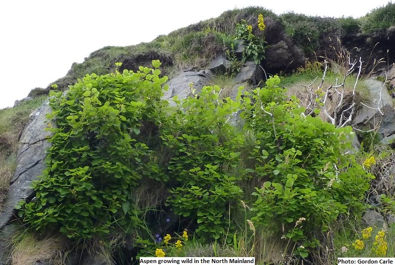
The Shetland Islands have been inhabited for more than 5,000 years. A fact that not many visitors realise is that the islands used to have extensive areas of shrubs and trees. Human occupation led to large clearances for agriculture, shelter and fuel. The introduction of sheep and other animals (rabbits etc) ensured that most seedlings which “popped-up” didn’t last long. In the last couple of hundred years humans have started to plant trees in plantations, often with non-native varieties. However, there are still remnants of native species where animals and people have found access difficult; for example, on islands in the middle of lochs and on cliff faces. The picture below shows some native Aspen on a very steep slope in the north mainland – the photo was taken in August. (Leftclick on pictures to enlarge).


The result of the relatively mild climate (no I’m not joking – compare it with places at the same latitude - Southern Greenland, Alaska etc), good fishing, good anchorages and land which could be farmed, has led Shetland to be well-populated for a long period.
What’s all this got to do with archaeology you may ask. The situation is that in this small land mass there are possibly more “archaeological sites” in a square mile than in any other part of the UK. There are many known sites which have never been “dug” and there are probably still many sites yet to be discovered. Factors which decide which sites are to be excavated include not only their perceived importance but also economics and their distance from the road! In summary, a great place for an amateur archaeologist (sometimes leading to disappointment when the “experts” don’t react as hoped and the find is “mothballed”).

Underhoull
The discovery of Underhoull is described in the article below from the Press and Journal in 1963. Below the article are 2 photos of “the dig” surrounded by civilians and serviceman,
The dig also featured in a later station magazine from the summer of 2000 “The Saxa Voice”, the 3 pictures below are from that issue:-


For those with a greater interest in the site I have put a link to a 28 page .pdf document written by Professor Alan Small who was in charge of the dig (It may take a moment or two to download). There have been further excavations on the site since the original efforts but I leave those who are interested to do their own research on the internet.
http://archaeologydataservice.ac.uk/archiveDS/archiveDownload?t=arch-352-1/dissemination/pdf/vol_098/98_225_248.pdf
 
Clugan
In 1970 a sergeant stationed at RAF Saxa Vord made another discovery on the east coast of Unst. The following article appeared in the Shetland Times:-

The Royal Commission on the Ancient and Historical Monuments of Scotland describes the site as follows:-

“An Iron Age and Viking site lies on a structural bench some 10m OD and 50m inland at Clugan. The site was excavated by Sgt. B Beveridge RAF, and revealed two distinct horizons. The lower showed no structural remains but a large quantity of pottery, some iron slag, pumice, and stone tools. The pottery is clearly of the Shetland Iron Age type, probably of the immediate post broch period. Section evidence suggested that the site had been systematically cleared and levelled before later structures were built. The only structure on the upper horizon on the area so far excavated was a Viking cremation burial with no grave goods. The stones at the eastern end are still in situ but those at the other end had disappeared. Clearly defined post holes with packing marked their position. The stray finds from the upper 20 cms of the soil included numerous fragments of massive steatite vessels typical of the Viking period in Shetland, suggesting that a longhouse lies nearby.
Small, A 1970;
Information from Sgt. B Beveridge to OS 1970
Site located at HP 6439 0646 by OS field surveyor (K Frost) 8 May 1970”

Most Northerly House Site in UK?

The only information I have about this site is that which is contained in the short article that appeared in the Daily Mail which is reproduced below:-

CONTENTS LIST